


La Bastidonne - sommet des Bruisserettes - chapelle St Julien

mhetpierre
User
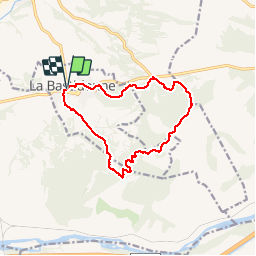

Length
12.8 km

Max alt
479 m

Uphill gradient
319 m
Km-Effort
17.1 km

Min alt
280 m

Downhill gradient
319 m
Boucle
Yes
Creation date :
2019-02-22 10:04:32.572
Updated on :
2019-02-22 17:42:40.145
4h12
Difficulty : Very easy

FREE GPS app for hiking
 SityTrail
IGN / Geographical institutes
SityTrail Plus
The world is yours!
About
Trail Walking of 12.8 km to be discovered at Provence-Alpes-Côte d'Azur, Vaucluse, La Bastidonne. This trail is proposed by mhetpierre.
Positioning
Country:
France
Region :
Provence-Alpes-Côte d'Azur
Department/Province :
Vaucluse
Municipality :
La Bastidonne
Location:
Unknown
Start:(Dec)
Start:(UTM)
706763 ; 4841774 (31T) N.
Comments